City of Frederick planners are proposing a four-lane, 50 mph road to run through Fort. Detrick’s Area B, the same Area B that is home to a Superfund in the middle of the City of Frederick.
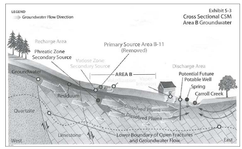
Fort Detrick Area B groundwater was proposed to the National Priorities List (NPL) in September 2008. According to the Site Plan Draft for Area B, “A response action was deemed necessary to protect the public health and safety and welfare or the environment from actual or threatened releases of hazardous substances or pollutants or contaminants from the sites that may present an imminent and substantial endangerment to public health and welfare.” According to the US EPA, the site is not finished being characterized.
When this land was placed on the NPL, Fort Detrick entered into a Federal Facilities Agreement between the US EPA and the US Department of the Army to ensure that the environmental impacts associated with past and present activities at the site are thoroughly investigated and appropriate remedial actions are taken, as necessary to protect the public health and welfare, and the environment.
There are currently two immediate issues to be aware of on Area B: 1) the groundwater plume, (see this link to learn more about how EPA defines groundwater plumes) which is on the NPL, and 2) the unlined landfills, which have been capped, and are considered for “no further action except monitoring for future releases.”
The main contaminants in the groundwater plume are Trichloroethylene (TCE) and Tetrachloroethylene (PCE), Dichloroethylene (DCE), chloroform and vinyl chloride. TCE and PCE are both known carcinogens above 5ppb in drinking water. The highest contamination on Area B borders the Waverley View Property, which is a field set back from Shookstown Rd and Kemp Lane. TCE has been found on the Fort Detrick side at a level of 15,000 ppb, and also outside Fort Detrick on the Waverley View Property in the groundwater at 340 ppb. This plume is believed to emanate from the source area (Area B-11), though this has not been 100% characterized according to the EPA.

A portion of the plume in the groundwater has followed gravity in the underground Karst system and traveled west under a small portion of the Waverley View Property. No homes are currently built there. The rest of the plume travels east following the groundwater. The plume discharges at several hundred gallons per minute into Carroll Creek where the highest level of TCE in surface water was found at 3.6 ppb, behind Montevue and Rosemont Avenues. The levels at the discharge area are below Maximum Contaminant Levels (MCL) except for a few detects up to 13 ppb in various seeps and springs that connect to the creek. This plume does not stop at Fort Detrick’s fence line; and TCE and PCE do not break down easily, if ever, in a Karst geological system. When they do, they become vinyl chloride, a much more dangerous contaminant. Fort Detrick has recently begun a few pilot studies to assess the potential remediation strategies.
In addition to this Superfund Groundwater Plume, Fort Detrick is home to unlined landfills on Area B (one of which is believed to be the source area of the groundwater plume). Most modern landfills have to have a liner, but these do not. Area B was used as a test grid for biological experimentation of simulant biowarfare materials (FFA p9). The remains of experimentation were buried in some of these landfills in Area B, with B-11 of particular concern. What is known to be there includes but is not limited to: chemical, radiological, and biological toxins including non-virulent anthrax, bacillus globigii, eschera coli, animal carcasses, and phosgene. According to the FFA, “documentation shows that the landfill pits and their locations were not accurately documented.”
Anticrop research was also conducted in Area B. The waste residuals of the demilitarization process were eventually placed in a landfill on Area B. This is the same landfill beside which City of Frederick planners propose to construct and run a four-lane highway, just ten yards away.
In 2004, the Army began a removal action in this landfill. Their contractors unearthed 3,500 tons of contaminated soil from here and trucked it to a Texas incinerator for disposal. Before they could continue, according to the EPA, it was reported that while excavating one of the trenches, the sides collapsed revealing amber bottles, partially or fully intact, at around four feet below the surface. While moving the material within the trench, a small plume of white vapor, gas, or smoke, was observed emanating from the trench. The Army reported to the EPA that the combination of the quantity of laboratory waste being found, coupled with the chemical reaction during the trenching activity, prompted the army to cease the intrusive investigation, backfill the area, and place a cap on top.
Though there are now caps, these landfills are still unlined. This action is considered a “Remedy in Place.” The cap over the top of the remaining contamination helps to keep rainwater from pushing the contaminants further down into our soil and groundwater. To sum up, biowarfare contamination remains, in place, in a landfill, jus ten yards from where the City of Frederick proposed road will be.
The human health risk assessment for this area, as stated in the Site Management Plan, identifies hypothetical exposure pathways for the site. They include:
- site workers and visitors potentially ingesting, contacting, and inhaling contaminants on the site,
- off site residents potentially inhaling airborne contaminants including contaminants that may have migrated via surface water.
Contaminants found here, according to the Army’s contractor, are still source contaminants. The current risk assessment by the Army’s contractor is based on the assumption that this tract of land is to remain open space.
The army entered into a one-year Memorandum of Understanding (MOU) in 2009 with the City of Frederick to establish cooperation for consideration of an easement through Area B for this road. That MOU is expired. This road had been in the planning process long before we had new safety data placing Area B on the NPL and pre-dating our knowledge of what exists in the landfill or follows our groundwater in the plume. Yet the City continues to spend tax dollars to plan this road.
The City has completed their Environmental Assessment (EA) and will submit it to the Army. The EA looks at the “big picture” and not the specifics of Area B. There will have to be a Risk Assessment as well. All steps, when submitted, will have to go through the Maryland Department of Environment (MDE), the EPA, the Army, the Garrison Commander and then Army headquarters. For ten years the regulating agencies have sent the Army back to the drawing board to fill data gaps. The City will likely also have a time-consuming process navigating through all of the same agencies for approval for intrusive activity on this site.
Once a site is considered by EPA to be a Superfund site, all entities involved follow a set of laws created under Comprehensive Environmental Response, Compensation, and Liability Act (CERCLA) (also known as Superfund).. Under these guidelines, Fort Detrick is charged with providing a remedial investigation, a feasibility study, a selection of remedy, a remedial design, a remedy action, and then maintenance and monitoring. We still have new site inspections opening, to fill data gaps about this contamination. We are years away from remediation, as well as decades of monitoring.
Fifty years ago, current safety standards saw no harm in burying biowarfare waste in an unlined landfill. Ten years ago, the Army claimed they were almost certain that the contamination would not be detectable in Carrol Creek; ten years before that another government agency did not see the need for any further testing. Yet today we are on the National Priorities List due to an imminent and substantial threat to public health and safety. What we now know changes safety data, as more testing occurs. It would be prudent for the City of Frederick to not wake the dragon at Area B. The Superfund process is convoluted enough without adding the road through Area B. The City, honoring a Duty of Care, should pursue another route for this road.
If you would like to see the city cease and desist planning this road through Area B, please write to the Aldermen, Mayor, and City Planning Commission. They are currently drafting and voting on an updated Comprehensive Plan that includes a section with their intention on constructing the “Fort Detrick Road.”
Jennifer Kunze of Clean Water Action, Elizabeth Law a RAB (Restoration Advisory Board) member, and I, also a RAB member, have drafted, submitted and suggested edits to their current Comprehensive Plan draft renaming this section “Christopher Crossing Loop,” and deleting from it the intention to continue to plan this road through Area B. We have also written and submitted edits that we believe allow the Planning Commission to offer “guidance” for developers regarding Master Plan Approvals that fall in this area, such as when a Vapor Intrusion Barrier may be necessary and/or Right of Entry for monitoring. If you would like to see our suggestions or have any questions feel free to reach out to us. The next meeting the Mayor and Alderman will have about this is in the coming month. Until then you can email them with your concerns.
If this is concerning to you, please email the Aldermen and Mayor with your thoughts, as well letting them know that you support keeping the language regarding Fort Detrick in the 2020 Comprehensive Plan (as long as they consider the proposed edits to the current draft). Even though the draft of the 220 Comprehensive Plan is with the Mayor and Aldermen, you can also email the Planning Commission to let them know of your concerns about this road.
our emails:
Jen Peppe Hahn jphahnlmt@gmail.com
Jennifer Kunze jkunze@cleanwater.org
Elizabeth Law bettybob1758@gmail.com
City of Frederick Comprehensive Plan
EPA Superfund Site Information
Fort Detrick Environmental Management Division
Jen, the author, is a lifelong resident of Frederick County and has been involved with the issues surrounding Ft Detrick since 2010.